Categories
The General Synopsis At Midnight

Lost at sea: areas Hebrides, Malin, Trafalgar, Biscay… and the Baileys

Lusitania posterThe ocean floor is a surprisingly busy place. Teeming, you might say, with lost life. The UN reckons three million shipwrecks are scattered around the bottom of the world’s seas. Small yachts and fishing smacks, Viking longboats and German U-boats… the sea now owns the lot, regardless of what governments or salvage operators might think. The Irish sea area claim to fame is that there are said to be more ocean liners and U-boats sunk off Malin (on the Inishownen peninsula, Malin Head is the most northerly point of Ireland) than anywhere else in the world; the majority of them casualties of the World Wars.

When I went to the Isles of Scilly Museum – a place founded in 1963 because of a need to house all the finds deposited on the beach by winter seastorms – I was surprised by the contents of a display of bits and bobs washed up from the 1997 wreck of the Cita: tyres, Luck of the Irish keyrings, Dunnes Stores ‘St. Bernard’ brand shoes. It must be years since Dunnes decided that the luck of the Irish had run out as far as St Bernie was concerned and put him out to pasture. I always thought a C12th French century monk best known for his persuasive way with words was an unusual choice for a shop’s own-brand merchandise. (There were a few obligatory miracles of course, such as ridding churches of flies, and curing a child’s withered arm, but Saint-wise he wasn’t one of the biggies as far as I can see. Maybe Dunnes were referring to the dog?) Anyway, back to shipwrecks. On that trip, my flight back to Exeter from St Mary was delayed and to kill some time I flicked through a copy of the Wreck of Colossus – The Find of a Lifetime, which I found lying around in the café in St. Mary’s tiny aerodrome (okay, technically it was for sale, alongside handcrafted doilies and flower-illustration postcards, but I handled it gently).

Todd Stevens went to Scilly as a Cita salvage diver originally and ended up staying. Diving alone one day, he found a previously unknown additional site of the HMS Colossos, the 74-gun warship that sank in 1798. The ship was famously jam packed with a collection of Etruscan pottery belonging to Sir William Hamilton and – less famously – full of wounded soldiers on their way home from the Battle of the Nile. With his wife Carmen, Todd Stevens continued to explore this new area. Lying face upwards on the sand she found the most incredible thing: a twice life-size carved wooden figure that was once was part of the Colossos’ stern decoration (that’s it on the right). What struck me most about Todd Stevens’ book – and I didn’t get to read it all because a) I was out of sterling and b) my flight was called – was how honest he was about the thrill of the chase in salvage diving, and the frustration of having to leave a possible site behind and return to land. He makes it sound so addictive, the belief that just there, over there, under that rock, behind that reef, a moment of history lies trapped. A giant-sized, barnacle-encrusted ‘what if’. tresco-oscar-colossus-figurehead-2

But when something wonderful, such as the carving from the Colossos, is found, what happens then? So often it is conditions of the sea itself that can preserve wrecks and their booty. Removing them from these crypts sends time spinning forward. Shipwreck sites are nearly always graves as well as treasure chests. Understandably, the focus on the human cost of a shipwreck gets more prominence the more recent the disaster. Whizz back in time and the people tend to get forgotten about. We will never know who were the crew of fifteen on the 3,000 year old paddle-powered boat discovered in sea area Plymouth in 2009. Its cargo of copper and tin ingots, a bronze sword and three gold torcs are seen as evidence that there was a much more sophisticated European communications and trading system in operation than was preciously believed. Engineer Jim Tyson who took part in the dives said: ‘You have something in your hands that had not seen the light of day in 3000 years. The last person to do so must have died in the shipwreck.’ A thoughtful comment to make, considering that the temptation must be to jump up and down in delight with joy at finding a haul dating back to 900BC.

Underneath the invisible lines that create the jigsaw that is the Shipping Forecast, all the sea areas have their own shipwreck secrets and stories. One of the quirkier ones is that of the SS Politician, which was fictionalised as the SS Cabinet Minister in the in the novel Whisky Galore! by Compton MacKenzie. An 8,000-tonne cargo ship, the SS Politican left Liverpool on 3rd February 1941, heading for Jamaica and New Orleans. Two days later she ran aground of the northern coast of Eriskey in the Outer Hebrides during a gale. The crew all survived and spilled the beans about the ship’s cargo to the locals. A clue as to said cargo is in the title of the book. Yip, malt whisky. And galore. 264000 bottles of the stuff in fact. Thanks to wartime rationing the island’s own supplies of whisky were long gone, so who could blame them for deciding to help themselves before the seals got the lot? It wasn’t stealing, according to the enterprising fishermen who dressed as women so as not to be caught with telltale oil stains from the ship’s hold on their clothes. Nope, all was fine and dandy, according to the rules of salvage. Problem was, the local customs and excise officer thought otherwise: Charles McColl insisted the police take action, with the result that a number of islanders were convicted. Their sentences ranged from a £3 fine to six weeks imprisonment. The Politican proved resistant to official salvage attempts and – this being wartime, you can imagine how distracted the bods in charge were – it was decided to simply leave the stricken ship where she was. McColl estimated that 24,000 bottles had been stolen already and that simply abandoning the ship to its fate would prove too much temptation, so he got permission to explode her hull. Now that must have been some sight for the recently drunk, also recently hungover but now sadly newly sober, islanders to witness. Whisky Galore was released as an Ealing comedy in 1949. I wonder if Charles McColl ever saw the movie?whisky-galore-poster-1-1024x770

In the same month the SS Politican brought such brief, unintended happiness to the Hebrides, the SS Gairsoppa took a direct hit from a German U-boat’s torpedo. It sank in less than 20 minutes at 50 degrees N, 14 west, close to where sea areas Shannon and Sole meet. Only three of the crew managed to escape in a lifeboat. They reached Cornwall two weeks later, where two of them died trying to get ashore. Last year, 2,792 silver ingots worth €27m were recovered from the site three miles (!) below the surface. Despite this massive haul, the SS Gairsoppa is relatively small beans compared with Ireland’s other shipwreck connections. Our biggest claim to shipwreck fame is generally taken to be the Belfast-born Titanic, which sank on its maiden voyage in 1912. However, fascinating as its story of hubris is, I’ll see your Titanic and raise you the Spanish Armada.
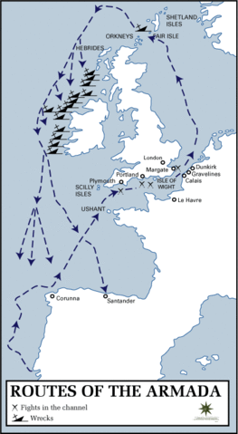
263px-Routes_of_the_Spanish_ArmadaThe route followed by the Spanish Armada – both intentionally and not – by this fleet begins in Sea Areas Trafalgar and Biscay. In fact, it covers most of our Shipping Forecast map, not that even the word ‘forecast’ would have made any sense at the time, this being centuries before Sir Robert Fitzroy.

In September 1588 Philip II decided he’d take a pop at invading England, and sent a fleet of 130 ships carrying almost 30,000 men with that express purpose. It didn’t go well, this tale of old against new: the heavy galleons of the Spanish were more like floating castles than ships, versus the newer Elizabethan ‘race ships’ that were low and fast, with much lighter armoury. The beautifully named Battle of Gravelines sent his fleet, well, fleeing. As the remaining ships tried to scarper, a combination of bad weather and poor navigation drove them towards the west coast of Ireland. Queen Elizabeth was concerned about a possible Irish/Spanish alliance against her and so her man on the ground Sir Richard Bingham (a tough cookie, as pirate queen Granuaile was soon to discover, and you can read about here) and the Lord Deputy William Fitzwilliam issued orders: “to make inquiry by all good means, both by oath and otherwise, to take all the hulls of ships, stores, treasures, etc. into your hands and to apprehend and execute all Spaniards found there of what quality so ever. Torture may be used in prosecuting this inquiry.” Ouch. 24 Spanish ships were wrecked off the Irish coastline, and it is estimated that 5,000 men died. In the centuries since, 10,000 pieces of treasure, from forks to cannonballs and rubies to coins, that once journeyed through what we know as Trafalgar and Biscay, have washed up on Irish shores.

And finally: to Bailey. Not the sea area this time, but a person. Two in fact. Maurice and Maralyn Bailey decided to move to New Zealand and so in June 1972 they set sail from Southampton on their 31-foot yacht, the Auralyn. Everything was going fine and dandy until, off the coast of Guatemala, a whale got up close and personal, with the result that – well, you can imagine the result. They roped their dingy and life-raft together and grabbed what supplies they could. From the dingy they watched their yacht disappear. In a diary entry dated March 4 1973 (but written after the event), non-swimmer Maralyn Bailey wrote of “a violent impact. The ship shuddered and there was tearing, splintering wood. We looked at each other. I dashed outside. As I went into the cockpit, I saw, off the stern, a huge whale. Around him the deep blue water was stained red“. If they had been told on that morning that they would still be on that small raft 117 days later, I wonder would they have stayed put or jumped in after the Auralyn? When their supplies ran out they survived on rainwater and by catching turtles, birds and even small sharks with their bare hands and a safety pin. Seven times other boats were nearby and failed to spot them as they drifted in the Pacific becoming increasingly malnourished and weak. 1,500 miles later the Baileys were spotted by a Korean fishing boat, the Weolmi 306. They had each lost 40 pounds in weight and could barely stand. The water had rotted their clothes and their bodies were covered in sores. In their 1974 book 117 Days Adrift (published as Staying Alive! in the US; please note the jaunty exclamation mark.) they wrote that to keep their spirits up they played dominoes and cards made out of pages ripped from a notebook; and drew up elaborate plans for celebratory feasts.

A year later the Baileys were back at sea in the Auralyn II.SS Hop - Unst

—–
I came across this plaque dedicated to the crew of the SS Hop in a graveyard on Unst in the Shetlands in sea area Fair Isle. You can read about that trip here.

Oh, and if you think the Titanic was spectacularly ill-fated, then spare a thought for the Vasa, a Swedish warship that too sank on its maiden voyage. To be fair to the Titanic, she did get a fair bit into the journey before that iceberg got in the way. In 1628, the Vasa managed only to get 1,300 metres away from dock before foundering. In the 1950s the Swedes dug the ship out of what had become a busy shipping lane on the outskirts of Stockholm’s harbour. The custom-built Vasa Museum is a hugely popular tourist attraction, and the ship has become a symbol of what is known as Sweden’s ‘great power period’. (Not, you note, of a great shipbuilding period.)

—-
The General Synopsis At Midnight is my exploration of the sea areas of the BBC R4 Shipping Forecast, thanks to the Maeve Binchy Travel Award. The earlier post ‘Counting Down To Midnight’ explains the project. A piece based on the project called ‘The Shipping Forecast’ broadcast on Sunday Miscellany, RTE Radio 1, November 2nd

Want to sea more?

Warships, U-Boats and Liners: A guide to shipwrecks mapped in Irish waters by Charise McKeon, Karl Brady, James Lyttleton and Ian Lawler. Published by The Stationery Office, Dublin (2012).

117 Days Adrift by Maurice and Maralyn Bailey published by A&C Black.

There are plenty of Irish resources about the Spanish Armada, such as http://www.sligoheritage.com/ArchSpanishArmada.htm and http://www.clarelibrary.ie/eolas/coclare/history/spanish_armada.htm

And thank’ee Wikipedia for the Spanish Armada map.


Categories
The General Synopsis At Midnight

Sea areas North Utsire, South Utsire, Viking, Fair Isle, Shannon, Southeast Iceland: Messages without bottles

I didn’t dip a toe into any sea area for The General Synopsis At Midnight this week, instead I experimented with time-travel.

Once upon a time, and not as long ago as you might think, Iceland simply didn’t exist. It was nothing more than the faintest wisp of a myth. Then, early in the ninth century an Irish (hurrah!) monk called Dicuil – now there’s a name you don’t hear shouted across many playgrounds – wrote about Irish pilgrim monks spending the summer on a remote land. And that’s the first recorded mention of the country. Not of the people, nor the volcanoes, nor the sea-bright air. The country. There were no people to construct unfathomable megalithic cairns. No-one to drop a darn-and-it-was-my-lucky-flint-too arrow-head. Over a thousand years before Dicuil took quill to parchment, a Greek explorer called Pytheas of Marseilles came up with the idea of land six days’ sail from the north of the British Isles. He called it Thule. Because it was the most northerly point anyone could imagine it became known as Ultima Thule. And even it wasn’t Iceland. (What Pytheas had come up with was most likely the Shetlands, or depending on how speedy a sailor his calculations were based on, possibly Norway).

Dicuil set the bar for travel writing high, partly because he described the country so evocatively, partly because he believed it actually existed. Of the permanent daylight in summer he wrote, ‘The setting sun hides itself at the evening hour as if behind a little hill, so that no darkness occurs during that brief period.’ Dicuil added that it was possible to pick the lice from your shirt as precisely at night as in daytime, thanks to the light. Clearly, here was a man who understood the vagaries of travel. (On Unst recently I was told this perpetual midsummer daylight is known by the lovely title ‘the Simmer Dim’).

Although they had yet to settle in Iceland, Vikings had been firing themselves at northern and central Europe for some years before Dicuil recorded the monks’ visit. The Viking age is generally considered to have started in 793AD, when they decided to have a crack at Lindisfarne, an island off the northeast coast of England. The Anglo-Saxon Chronicle – a thousand-year old series of manuscripts charting the history of the Anglo-Saxons, not a British local paper chock full of small ads, in case you’re wondering – recorded, ‘In this year fierce, foreboding omens came over the land of the Northumbrians, and the wretched people shook; there were excessive whirlwinds, lightning, and fiery dragons were seen flying in the sky. These signs were followed by great famine…’

I like to imagine a couple of young monks standing at the door to Lindisfarne while marauding Norsemen stream up from the water’s edge like crazed sea monsters. One monk sucks his teeth and says, ‘Here, there might have been something in those whirlwinds after all.’
Excessive whirlwinds,’ says his pal.
‘Yeah. There was all that lightning too.’
‘And the dragons.’
‘God, yes! I’d forgotten about them.’

Over a thousand years later and all the countries of the Shipping Forecast have grown close to each other without having moved. Should we choose to now, we can find out what each other is up to all the time. We know each other’s weather – in fact, we make it our business to. Everything is transparent. Which made the recent BBC report Why Icelanders are wary of elves living beneath the rocks even more intriguing. With the constant prospect of invasion in island countries, it is easy to understand ancient beliefs in spirits of land and water. Forces that could protect and warn, that could provide shelter but just as easily cause harm. Belief in land-spirits is thought to have become especially strong in Iceland primarily because of its isolation. Land-spirits – ‘Landvettir’ – were powerful, responsible for the welfare of the land. Modernity doesn’t seem to have entirely done away with these beliefs: in a survey in 1998, 54.4% of Icelanders said they believed in the existence of elves. Why Icelanders are wary of elves living beneath the rocks claimed that work on a new road linking the Alftanes peninsula to a suburb of Reykjavik called Gardabaer was halted when campaigners warned it would disturb an Elf Chapel and a protected area of untouched lava. A local woman who claimed she could talk to these Huldufolk (believed to be the same size as humans, but invisible to us) mediated. The road went ahead on the basis that the roads department would carefully move the Chapel – aka a dark and craggy, 12 foot high rock – elsewhere. A pro-elf protestor commented, “To have people through hundreds of years talking about the same things… It is part of the nation.”

In Norway – a land that resembles a crackle of frost on a winter window, where the landscape itself is brought to life in stories of giants – the tomte was a benign spirit who took care of a farmer’s house, but only for farmers who worked hard. On Shetland it was once commonly believed that the hills and the sea were full of mysterious creatures, some more harmless than others. Music-loving fairies called trows lived underground in heather-covered knowes and went about their work at night. Shetland’s fishermen had a special language for use at sea. It was a form of code, just as the Shipping Forecast is. They did not refer to ordinary objects by their usual names, because they thought that would invite danger onto the boat. John Spence wrote in his 1899 book Shetland Folklore, “The movements of witches were always made against the sun, and by whirling a wooden cap in water … they were supposed to be able to raise the wind like Furies, and toss the sea in wild commotion capable of destroying anything afloat.” People travelling at night near streams and marshy ground kept an eye out for ghostly horses called nyuggles (top image). Should an exhausted traveller not realise what they were dealing with and hitch a free ride, the nyuggle would bolt for the nearest water. It never ended well, as you can imagine. The water spirits in Norway skipped the horse bit entirely and were said to take the form of a devil, eager to lure people to a sure death by drowning.

The famine that supposedly preceded the Viking attack of Lindisfarne reminded me of a story told to me by my grandmother a few years before she died. In 1921 she was eighteen and moved from Mayo to Cork to train in animal husbandry at the Munster Institute. She then got a job as a poultry instructor with the Department of Agriculture. She was the first woman in the west of Ireland to buy a car, she said. Seventy years later she still had a photo of the two of them together, with her leaning proudly against the driver door. (She would have been horrified by my timidity on Shetland with my rented Mirage.)

Her route around the farms of the west of Ireland took in the Aran islands; Inis Mór, Inis Meáin and Inis Oírr. Leaving her little car behind her on the mainland, she would stay on the islands for two or three days at a time, sometimes more if a storm got up and the boat couldn’t sail back. The islands were beautiful and she always enjoyed walking for miles around them going from farm to farm, crossing the fields at whatever place she chose. At first the farmers told her that she had to follow the roads and paths but she wouldn’t, which would have been typical of her I suspect. She must have been confident that no-one would make trouble for an Instructor ‘over from the Department’. She liked the locals so she never really minded getting stuck for an extra day, even though some of the lodgings were rough. On one of her visits she’d stayed in Inis Mór’s only hotel – such as it styled itself – and had woken up to find a rat sharing the pillow with her.

One morning on Inis Mór – which older islanders often called by its former name, Inis Bant – she set off to walk to a farm some miles away. She was enjoying the walk because it was a lovely fresh morning and she was as good a walker as she was a driver. All of a sudden she began to get hungry. It was the weirdest thing, she said, but she got hungrier and hungrier until her head was spinning and her knees crumbled under her and couldn’t go any further. It was the most she could do to pull herself along by the ditch as the grass around her appeared to be going black in front of her eyes. She was about to die, she was sure of it. And she was sickened that she’d never see her lovely car again, and worried would her mother know where to find her other prized possession, a gold medal King George had presented to her the year before, at the 1925 Royal Agricultural Show. Just as she realised she wouldn’t be able to crawl another inch, she heard a shout and from nowhere, a man grabbed her arm and dragged her over the ditch and onto the road. He pulled a piece of bread from his pocket and as soon as the bread went into her mouth she was immediately better, not hungry or thirsty at all. ‘Are you a mad woman?’ he said and before she could answer he turned and strode off. She was to be back on the island many times after that day but she never saw him again.

She had strayed onto Hungry Grass, she believed: famine grass, where a starving person had died. Planted by fairies, according to some. Nearly seventy years later, she ended her story with the advice, ‘always keep something small to eat in your pocket,’ and with a last, decisive click of her dentures, added, ‘hungry grass can trick a person, because it looks the same as any other.’

viking longhouseStories are messages without bottles. Travel changes them, just as it does people. The Icelandic word saga is a cousin by marriage of the Old Norse segja, ‘to say’, which makes me wonder what a folklore map that covers the same territory as the Shipping Forecast would look like. Would there be any definite lines, any careful delineations? Wouldn’t those areas that don’t touch any land be entirely redundant, mere passageways from one harbour to another? I picture folklore and fairy tales moving invisibly through the air just as seeds are carried inside birds. Words hewn in Viking longhouses (the photo is of a reconstructed one on Unst), cast adrift in Norway and washing ashore in Scotland and Iceland and Ireland.

Unst, next stop NorwayStories were stowaways on Viking ships. Myths were breathed between monks patiently guiding their lonely rowboats to unknown lands. Huldufolk, trowes, tomte, the Little People… these are grafted from one tradition to another. Our lives are tales told in the cries of cormorants. Our fears cross dark seas, whispered by the waves.


The General Synopsis At Midnight is my exploration of the sea areas of the BBC R4 Shipping Forecast, thanks to the Maeve Binchy Travel Award. The earlier post ‘Counting Down To Midnight’ explains the project.

The Nyuggle was photographed from a line drawing used in a display board at The Shetland Museum and Archives in Lerwick. It’s a fantastic museum and worth exploring online if you can’t get there in person. www.shetland-museum.org.uk

Want to sea more?

Why Icelanders are wary of elves living beneath the rocks: http://www.bbc.com/news/magazine-27907358

Old Norse-Icelandic Literature, a short introduction by Heather O’Donoghue. Blackwell Publishing 2004.

A big thank-you to Eilis Ni Dhuibhne for introducing me to the mystery and beauty of the folklore tradition.

Categories
The General Synopsis At Midnight

Sea areas Cromarty, Forth and Fair Isle: “Only men’s minds could have unmapped into abstraction such a territory”

Once known as ‘Area Shetland’, this sea area was divided into two in 1932 only to be reunited as ‘Area Fair Isle’ in 1949. The journey to the Shetlands from Edinburgh passes over areas Cromarty and Forth on the south east of Scotland.

My name is Henrietta and I’m a nervous driver. There. Now you have it. I hang around Sumburg Airport for as long as I can. The keys to the smallest three-door car available are hot in my pocket but I’m ignoring them. I go to the toilet. I flick through the paperbacks on the take-one-leave-one bookstand (other airports, please take note!). I go to the toilet again. I think about following a bloke who looks like a chap off the telly to see if a better glimpse would help me figure out who he is. I visit the toy puffins in the shop, and give a baby one a little squeeze for reassurance. But there’s nothing else for it. I’m either going to bed down in the airport for the rest of the week, or I’m going to go outside the tiny terminal building and bleep-bleep the alarm on my first-ever hire car. And then drive it.

I leave the airport terminal – which looks as though it were built from bits left behind from the construction of the Ballycotton Hilton (see previous post) – and walk into an early prototype of a Dyson Airblade. But with rain. Reassuringly, the Mitsubishi Mirage seems to be approximately two Shetland Ponies horsepower. About half a mile down the road I spot flashing lights ahead and join a queue of cars stopped behind a barrier. I wait, wondering what’s going on yet grateful for a break from the mysteries of the Mirage’s windscreen wipers. I know there’s no train service here. Sheep maybe? There are plenty of them. Then the traffic moves forward and as I drive over a suddenly wide and smooth road I realise that the main road bisects the airport landing strip. I’m driving across Sumburgh airfield.

Shetland is made up of over 100 islands, 15 of which are inhabited. The drive from Sumburg on Mainland, the largest and most populated one, to Unst, the most northerly point of the UK, takes three hours and two ferries. The sheep theme continues, now with the addition of Shetland Ponies. ‘Look,’ I tell the Mirage. ‘Your cousins.’ It is too busy cantering up yet another hill to answer. The terrain is wonderful; wild and lonely and oddly dignified in its bleakness. Random bungalows abound as freely as sheep. It reminds me of Achill Island in Mayo: a terrain scarred by what has been built on it. The grey hills in the distance ahead have other, darker grey hills behind them. This land is its own echo. Flames burst into the sky from a vast chimney: the Sullom Voe pipe, burning off the gas that is a by-product of the oil. (But I’ve just arrived, and as I drive away from Sumburgh I don’t yet know what that pipe is, or that the locals suggested this unwanted gas be piped to them for free only for the powers-that-be to decide to waste it instead. No, on this day all I can see is an unexpected orange flare, far in the distance.)

The only people I spot are those huddled in distinctive red-frame bus shelters. I want to stop and offer someone a lift only I’ve no idea where I’m going myself. Grey clouds hang low as a migraine over the hills, pierced by a gauzy yellow beam that I never seem to get any closer to. Brighter later, I think to myself, and recall a woman on the flight from Edinburgh who had turned to her companion and said, ‘I think of this as my Shetlands coat.’
‘Because of the hood, you mean?’
She nodded. ‘There’s showers forecast.’
‘Aye, all-day showers,’ he said. ‘All-year, all-day showers.’
I am chasing Brigadoon.

While I’m waiting for the ferry to take me from Yell to Unst I tune into the lunchtime Shipping Forecast. Fair Isle: north or north-east five or six. Showers. Good. Occasionally moderate. So nothing much to worry about, I’m glad to hear, wondering was this forecast one of Craig Snell’s. (Should that sentence make you scratch your head, then the earlier post Meeting The Met Office will set you straight).

Unst is on the same latitude as Bergen in Norway and Anchorage in Alaska. It is an island of hills and water the colour of slate. It was a Scandinavian society from the 800s until in 1469, Princess Margrethe of Denmark married King James III of Scotland. The Danish king was short on funds for her dowry, so he pawned Orkney and Shetland to the Scots instead. The signposts remind me of the time I got lost in the textiles section of Ikea: Nikkavard, Baliasta, Hjarkland. Robert Louis Stevenson used Unst as the basis for his map in Treasure Island. His father and uncle were well known engineers who designed and built – among others – the Muckle Flugga lighthouse on the most northerly rock of the British Isles. Muckle Flugga is the edge of the edge. My first stop is Norwick beach. This area is an ophiolite; a section of the earth’s crust from beneath the ocean that collided with an ancient continent and was pushed up onto it 420 million years ago. (I think we all know I’m quoting the information board next to the beach here.) It is designated a Site of Special Scientific Interest, a title which manages to be formal and yet cheerfully vague all at once. The upshot is that what me and these seals are strolling about on was once at the bottom of the ocean. seals seals seals

The RAF Museum at the Saxa Vord Resort comes complete with café, bike-hire and chocolate shop. The large carpark is deserted. The resort appears to have no residents. ‘Where is everyone?’ I ask the man in the apron who runs all of these enterprises. ‘It was very busy earlier,’ he counters. ‘From 11 till 3, it was busy.’ ‘Oh,’ I say. ‘That’s good.’ But I’m thinking really? Until it closed in 2006, Unst was home to the UK’s most northerly RAF station. (Nearly everything on Unst comes billed as ‘most northerly’. Most northerly post office, hotel, bus stop… it’s the island’s USP.) The role of the base was to provide an early warning of air threats to the UK. From the 1960s until the fall of the Berlin Wall, fighters from here practiced bombing and missile runs. In an attempt to encourage staff to Unst, the RAF produced a manual, the first page of which reads: A posting for RAF Saxa Vord may seem to offer at first sight an unattractive prospect. But Shetland has much to offer the person who is willing to make slight adjustments to their way of life. The islands with their sense of history and adventure have great charm …. For example, you will see the New Year Festival of Up-Helly-A when a torchlight procession reaches its grand finale with the burning of a Viking Ship …. The islands abound in legends of trolls and giants.

Before I leave Saxa Vord I stop to read the notice board in the empty café. It’s the usual sort of stuff: Hom Bru Competition (‘no kits allowed’); Livestock Judging; Chinese Night This Friday! But going head-to-head with Chinese Night is another event billed for Friday – Rocky Mountain high! From Denver Colorado via the White House to Baltasound, Unst, An evening with Jim Salestrom. Flipping heck! I think. I saw him play in June. Not in the Baltasound Hall, Unst, but in the O2 as Dolly Parton’s guitarist. A second poster advertises Open Mic night with Jim Salestrom on Saturday and I go through my flipping-heck routine again. Possibly out loud this time, because the man in the apron pops his head through the swing door and looks at me. ‘Just going,’ I say. ‘Sorry.’

I head off to find the Underhoull and Lund Viking sites (the photograph is the Lund Standing Stone). You can’t throw a puffin in Unst without hitting a Viking site. The island has over thirty Viking longhouse sites alone. The Viking Unst project reconstructed a longship, and the one pictured here is the Skidbladner, a replica of the Swedish Gokstad ship that became stranded in Shetland during an unsuccessful attempt to sail to the USA in 2000. longship Lund standing stone

The girl behind the counter in H Henderson’s grocers tells me that they had 69mm of rain in Unst the previous Saturday. ‘But that’s nothing,’ she adds, ‘they had 128mm over on Fair Isle.’ ‘Hurricane Bertha, I suppose,’ I say knowingly, thinking I’m all about the weather, me. ‘Nah,’ she says. ‘That didn’t come in till later on.’ She’s known days where they’ve had rain, sun, fog and snow one after the other. Both Andy Yeatman and Craig Snell in the Met Office referred to calm or unremarkable conditions as ‘no weather’. This place is the opposite. Shetland is all the weather, all the time.

I do the reverse journey back to Shetland’s capital, Lerwick and to a b&b run by Eileen and Sandra. It’s owned by Sandra’s brother, but he went ‘back to the oil’ as she puts it. ‘The weather here isn’t in seasons anymore,’ Sandra says. Her daughter lives on a hill near Sumburgh and her house and that of her two neighbours were struck by lightning in consecutive storms. Sandra doesn’t mind the weather here, she’d take storms any day over the flooding that other parts of the UK and Ireland had last winter. ‘I felt so sorry for those people,’ Sandra says, ‘I’d hate to be flooded.’ (Craig Snell started his job as a maritime forecaster just weeks before the devastating storms of last winter, when record-breaking rainfall led to persistent flooding. It was quite the baptism of fire.)

In the fantastic Museum of Shetland at Hay’s Dock on Bressay Sound, I read that people have lived on Shetland for about 6,000 years. At Jarlshof there are remains of buildings from stone age to medieval times, and in the 1970s a burial site with the bones of 18 people more than 5,000 years old was discovered at Sumburgh. The display devoted to the North Sea Sullom Voe oil find (‘this black harvest from beneath the sea’), claims that the construction work displaced enough earth to bury all of central London one foot deep. The display features newspaper headlines from The Shetland Times. ‘The Oil Gushes’ gushes the headline of March 1972. Next to it is a cutting from June 1974: ‘First oil spill at Sullom Voe.’ It’s still a huge local employer and two floating hotels (see photo) are moored in Lerwick harbour to accommodate Sullom Voe employees. The sun is shining as I leave the building, but by the time I get my sunglasses out of my bag it’s raining again. The few touristy shops I pop into sell the usual seaside homewares bits and pieces, just as their equivalents did on St Mary’s in the Isles of Scilly. Shells laced onto strings with blue ribbons, limed wood plaques with nautical motifs. But they just don’t make sense here the way they do in Cornwall and Devon. Such sun-drenched tweeness needs a more orderly landscape.floating hotel

When I leave Shetland the water is the colour of gulls’ wings and the sky clears its throat over and over as we cross sea areas Fair Isle, Cromarty and Forth. Back in Edinburgh the hills no longer loom darkly over the town but have retreated to the distance, the painted flats of a stage set. The clouds are high in the sky once more. Back where they frame our days, rather than trying to walk among us.
Brigadoon is gone, swallowed up by a silver mist.


The General Synopsis At Midnight is my exploration of the sea areas of the BBC R4 Shipping Forecast, thanks to the Maeve Binchy Travel Award. The earlier post ‘Counting Down To Midnight’ explains the project.

next stop norway

“Only men’s minds could have unmapped
Into abstraction such a territory”
From the poem Celtic Cross by Scottish poet Norman MacCaig.

My reading during this trip was appropriately stormy: Rumours of a Hurricane by Tim Lott.

Categories
The General Synopsis At Midnight

Sea areas Sole, Lundy and Fastnet: a trip to the Isles of Scilly

My trip to the Isles of Scilly for The General Synopsis At Midnight project kicks off in rural Devon…

The taxi driver collects me in the village of Tipton St John. On our way to Exeter airport he careers down the narrow country lanes, calling out a giddy ‘whoopsie’ every time we round a bend and encounter another car. Where am I going, he wants to know. ‘That’ll do,’ he says, when I tell him about the Isles of Scilly. ‘That’ll do nicely.’ Yes, I nod enthusiastically. Yes, it will. Once collectively called Area Severn, these three Sea Areas of Sole, Lundy and Fastnet meet in a point just northeast of the Isles of Scilly. Sole doesn’t touch land, the other two have land boundaries. The flight from Exeter to Hugh Town on a 17-seater Twin Otter plane takes less than an hour and I spend a lot of that time looking out the window and mulling over John Gore Grimes’ comment about the invisible boundaries between one sea area and another.

The girl sitting next to me on the plane looks to be about 12 and worried to be travelling alone. Her magazine – which I sneak glances at – is full of teen dilemmas and ads for make-up and boy bands I’ve never heard of. Our pilot and first officer sit cosy-close in the small cockpit at the front of the plane. They leave the door to the cockpit open and the smell from the bag of bananas the first officer has hanging from his seat keeps me company for the journey. I’ve never been this close to the controls of a plane and the similarity between them and those of a car surprise me. Sure, this plane has a lot more knobs and dials and countery-whirly things, but it also has pedals and a tiny rear view mirror. (What could be behind us worth looking at? It must be for checking on the passengers rather than the rush-hour air traffic). At one point mid-flight the first officer twists in his seat and looks behind. He appears to be counting the passengers and I’m glad the girl is reading, her attention distracted by an article entitled How to Stage a Comeback.

The safety demo was a dvd shown at the boarding gate in Exeter. In it, a large man in glasses and a high-vis jacket demonstrated how to pop open a small window in case of emergency. Unwittingly, I realise I have chosen the seat next to emergency exit. ‘Did you watch the demo?’ the first officer asks me. I nod. ‘So you’re happy you know how to operate the window exit?’ I nod again, too nervous to mention that I was so busy wondering how the large man could possibly have fitted out the tiny window and whether he would have to take his specs off first, that I didn’t actually notice how he removed the glass. The girl looks over and I smile reassuringly. No bother, I hope my smile tells her; breaking windows is my specialty. I surreptitiously cross my fingers and look at the window instead, my attempts to silently figure out the push-pull of the frame forgotten when we leave Cornwall behind and fly over the sea. I watch the flickering, clock-hands reflection our propeller makes as it turns. The water below is the gemstone green of Murano glass. Ponderous container ships appear to be barely moving. There are occasional dense shadows that I decide are long-lost wrecks shifting deep in the water. A lonely lighthouse is the single structure on an impossibly tiny outcrop of rock.

The first glimpse of St Mary’s, the largest of the inhabited Isles of Scilly, is beautiful. It is all sweeps and arcs, with intricate cut outs that make it look as though it has been delicately laser cut. On either side of its squeezed waist are the yellow curves of beaches. The Isles of Scilly are 28 miles southwest of Land’s End. Five of 140 in this archipelago are inhabited – some barely so – and even the big ones are little. At three miles wide and about 10 miles all around, St Mary’s is strollable in a day. More than once, in fact: I clock up four town-wide strolls in the first afternoon. Old Town, Old Town House, Old Town Road: by the end of stroll one, I’m beginning to see a pattern in the nomenclature system. The charity shop on the main street of Hugh Town is called Charity Shop. Hugh Town is where the action is on St. Mary’s. It’s a pretty, blink-and-you’ll-miss-it sort of a place with an independent atmosphere that reminds me of Sidmouth, a town on the East Devon coast. Everyone I meet is talking about the weather. But isn’t it always like this in summer, I want to know. Hugh Town seems set up for heat. Designed for ice creams and salt-sticky faces. ‘Double your sun cream factor’, the bus driver had warned me. ‘You’ll fry otherwise.’ The island’s roads are being resurfaced and an Irish lad working there laughs when I ask him why everyone is going on about what a sunny day it is. ‘I’ve been here since February,’ he says, ‘and I’ve seen four seasons pass in four hours.’

Most people I chat to tell me that Harold Wilson is buried here on St Mary’s. In fact, so he gets so much airtime that I decide I’d better go and check out his grave on the far side of Hugh Town, in the 12th century Old Church. I bump into the Chaplain, who guides me through the graveyard. There is no crime here, he tells me. None. He never locks his house or his car. Children have to leave the islands to attend secondary school and before they go, they are taught what security means. (I pass a house later on – called, yes you’ve guessed it, Chaplain’s House – and notice the front door is wide open and I realise he wasn’t exaggerating). Harold Wilson’s grave is simpler than I had expected. A small bunch of fresh flowers rests against the headstone. A tiny red-hatted gnome stands on the granite edge. The Wilsons’ holiday home is nearby, I pass it as I walk back to the harbour. The curtains are closed. A small, plain stone bungalow, it puts me in mind of a breezeblock bunker outside a rural GAA hall. Perhaps the gnome strolled up from its garden.

It’s a hot, sunny afternoon and I am the only visitor in the Isles of Scilly Museum. The volunteer behind the cash desk thanks me profusely for coming in when I thank him for selling me an entry ticket. It is shipwreck heaven in here. In fact, the museum was founded in 1963 because they needed to house the Romano-British finds thrown up by that winter’s storms. One of my reasons for choosing the Isles of Scilly was the shipwrecks. You can’t swing a flip-flop in St Mary’s without hitting a shipwreck story. The Museum is home to many artifacts from the 1798 wreck the Colossos, which had on board the gems of noted collector Sir William Hamilton’s collection of Greek and Roman antiquities. It was found in 1975, and a second wreck near the site of the first yielded up its own long-hidden haul in 1999. Just as I’m about the leave the Museum I spot a display devoted to the Cita, which was en route to Ireland when she sank in 1997. She was on automatic pilot while all the crew slept when she ran aground. The Cita’s cargo spilled for miles around. The display features bits of tyres, St Bernard branded shoes, keyrings with ‘the luck of the Irish’ emblazoned on them.

A shipwreck I have never heard of before is the Thomas W Lawson. The world’s only seven-masted ship and largest pure sailing vessel without an auxiliary engine ever built, this schooner was destroyed nearby in a storm in December 1907. Its cargo of 58,000 barrels of paraffin caused what is believed to be the world’s first recorded oil spill. But the biggest shipwreck story is that of the wonderfully-named Sir Cloudesley Shovell. An Admiral of the Fleet, in 1707 he was sailing home in the HMS Association from a skirmish with the French when thick fog closed around his fleet. The story – given as true by Dava Sobel in Longitude, but disputed by some maritime historians – goes that one of the crew was a Scillonian and recognized the waters they were heading into. He disputed Sir Cloudesley’s reckoning that they were heading for Plymouth, and was so bold as to tell him so. Before the sailor had a chance to say ‘no, guv honest, I think that’s the Bristol Channel ahoy,’ Sir Cloudesley had him hanged for inciting mutiny. Not much consolation for the poor chap that he was proved right: within hours the Association, along with the Romney, the Firebrand and the Eagle, went smash-bang-wallop into the rocks. Only one man among the crew of close to 2,000 is said to have survived. Sir Cloudesley, his two stepsons and his dog apparently escaped on a small boat as far as the waters of nearby Porthellick Cove but most likely drowned trying to get onto the shore. A story persisted for many years that Sir Cloudesley did make it to land alive, but was murdered by a local woman for his priceless emerald ring and, in some versions, his shirt. It was decided that this disaster occured because the sailors could not correctly estimate their longitude, and as a result the Board of Longitude was set up at Greenwich in London.

I take a boat to St Agnes, the most southerly island. St Agnes makes St Mary’s look like New York. The winter population here is tiny. The summer tourist population swells the island, but most are day-trippers and so it falls quiet again in the evenings. From the harbour Porth Conger I walk past the decommissioned lighthouse to the inlets at Periglis Cove and St Warna’s Cove, named for the patron saint of shipwrecks. The further into the island, the quieter it becomes. I paddle around in the water, oddly aware of how far I am now from Cornwall and the mainland. Far out to sea is the lonely tower of Bishop Rock lighthouse and white-edged rocks break the water like old toothpaste smears on a sink.

I stop to read the community notice board. ‘If you have clothes for the fete please leave them in the snooker room’ it says, and it’s hard not to imagine the inhabitants as a casual sort of bunch, straight out of central casting for The Good Life, all happily buying each others’ cast-offs and stopping for a game of pool while they’re at it. St Agnes is connected at low tide by a sandbar to a tiny island called Gugh (pronounced Goo or Gue, depending on who’s talking). There are only two buildings on Gugh, each with a gently-curved aerofoil roof. I get chatting to a chap who turns out to be their owner. Gugh was uninhabited from the Neolithic period up until the 1920s, when an eccentric Irish surveyor decided to build himself a barn and a house. He is buried on the prow of the island, standing up. The current owner reckons he was quite a short chap, so that probably wasn’t as tricky a digging job as it sounds.

There is a home-made weather vane by the beach on St Agnes. A rough wooden cross, with a rope hanging down the middle and ‘Troy Town Weather Station’ written by hand across the top. (That’s it in the photo above). The dryness or otherwise of the rope determines the weather:

Rope : Forecast
Dry = Sunny
Wet = Rain
Still = Calm
Moves = Windy
White = Snow
Invisible = Fog
Gone = Force 10

The rope is dry and hangs perfectly still. I think of Craig Snell in the Met Office and the way the shipping forecast has its perfect codes, designed to convey so much with a single word. I stand on the beach on St. Agnes staring out to sea. Somewhere out there Sole, Lundy and Fastnet greet each other invisibly in the water. The only noise I can hear is the unsettling sound of gulls, their screeches the cries of unseen children.

____

The General Synopsis At Midnight is my exploration of the sea areas of the BBC R4 Shipping Forecast, thanks to the Maeve Binchy Travel Award. The earlier post ‘Counting Down To Midnight’ explains it all. Honest, it does… 

in the sea on st agnes

Categories
The General Synopsis At Midnight

Meeting The Met Office

Thursday July 24th and where better to begin The General Synopsis At Midnight than the Met Office? And where better in the Met Office than the desk where the Shipping Forecast is created?

Andy Yeatman is a thirty-year veteran of the Met Office. He has forecasted the weather, presented the weather and now, in his role as Deputy Head of Communications, has the unenviable task of explaining the weather to me. It’s all about dealing with uncertainty, he tells me. (That and understanding the Met Offices’ different audiences and their very different needs.) The Met Office HQ on the outskirts of Exeter – it moved to this purpose-built location from Bracknell some years ago – has the feel of a well-run and friendly small town. People are working in shared meeting spaces. Busy open plan offices spread out from a vast atrium. There’s a shop, a café, a gym. The Met Office employs 1,800 people at 60 locations throughout the world and on the Thursday lunchtime of my visit, it’s a busy spot. So despite what we in Ireland think, we’re not the only ones talking about the weather all the time.

Andy sits me down with Craig Snell, one of the team of Maritime Forecasters. The Chief Forecaster produces an overall forecast every six hours and it is Craig’s job to turn that forecast into the shipping briefing, using a computer model and a number of real-time information and observation sources such as ships and oil platforms. When the forecast is ready, he emails it to Radio 4 and the UK coastguard stations. He sits facing a triptych of screens. Today’s lunchtime broadcast on the desk in front of him and I am oddly thrilled at my one-hour-early preview of the Shipping Forecast. Craig’s job is to write a Forecast in as close to 350 words as he can (it goes up to 370 for the late night broadcast), giving as much information as is feasible, as clearly as possible. That information has to include sea-state, wind, weather and visibility but there’s only a limited palette of words he can use. No veering off into ‘a bit rough’ or ‘watch out there’ allowed. And yet he and the other Maritime Forecasters each have their own style and approach the information slightly differently. The priority in writing a forecast is to find what will have the most impact. As he puts it, ‘to concentrate on the things that would affect life.’ He suspects one of the reasons it’s popular with a generation older than his own is because they grew up with the Beaufort scale.

How many words are in his palette I wonder. Fifty-odd maybe? It reminds me of Humpty Dumpty in Alice in Wonderland, the way Craig can make a word work so hard. It is this repetition, he thinks, it what creates the poetry of the forecasts. ‘South’ appears in a single sentence several times, yet has a different meaning each time. For example, ‘fog’ can have only three adjectives: Patches, Banks and Extensive. More Extensive is allowed, if the fog is covering over half the area. There are no pea soupers at sea. Imminent means the first six hours of a given twelve-hour period, Soon means the second six hours. Visibility can be nothing other than Good, Moderate, Poor and Very Poor. Imagine if life was that simple, I think as I sit next to him and he explains these codes. Imagine day-to-day experience being that easy to grade and anticipate – and even to understand. Life would be simpler, that’s for sure. Would it be more interesting?

He tells me I can keep the copy of today’s lunchtime forecast. But before I stash it away, I ask him to sign it. Now that’s a souvenir.IMG_3445


Want to sea more? (Sorry) http://www.metoffice.gov.uk/public/weather/marine-shipping-forecast/#?tab=map

The General Synopsis At Midnight is my exploration of the sea areas of the BBC R4 Shipping Forecast, thanks to the Maeve Binchy Travel Award. The earlier post ‘Counting Down To Midnight’ explains it all. Honest, it does.

Categories
The General Synopsis At Midnight

Counting down to Midnight

Counting down to The General Synopsis at Midnight…

I stared yet again at my map of the 31 Sea Areas (see Map here). From Iceland and Norway down as far as the coast of Spain, the sea seemed to stretch on forever. And I remembered a many-years-ago edition of Mastermind and the four contestants with their four completely different specialised subjects. I couldn’t recall three of them. (The Moomin books of Tove Jansson perhaps, or something equally learnable; The Walls of Limerick, the Fjords of Killary.) The fourth person had ‘agriculture’ as their specialised subject. I imagined him lowering himself slowly down into Magnus Magnusson’s famous black chair and thinking, uh oh, maybe this wasn’t such a good idea after all. I’ve had what I’ve come to think of as my agriculture moments since I began to properly plan my exploration of the 31 Sea Areas of the Shipping Forecast. Too much sea! Too much land! Too many areas! But now that I’m counting down, and getting ready to visit to the Met Office in Exeter to see how the Forecast is prepared, I find that I’m getting excited all over again. Agriculture? A doddle.

The Shipping Forecast is broadcast four times a day on BBC Radio 4: 0048, 0535, 1201 and 1754. An essential tool for those at sea, it has become much more. Recently I met Captain Harry McClenahan of the Commissioners of Irish Lights, who talked about the power it has to transcend navigation. ‘At night, in a strange ocean you hear it,’ he said, ‘and it gives you a sense of security, and family.’ The music that precedes the late night broadcast is Sailing By, composed by Ronald Binge in 1963. Many listeners regard this waltz as a soothing lullaby, yet for Harry it doesn’t depict calm weather conditions, but rather is all about movement. ‘It is a painting of the sea,’ he said. Already I owe both Harry McClenahan and John Gore Grimes of the CIL a big thank-you for their help and advice. (For Shipping Forecast novices, https://www.youtube.com/watch?v=HnQ2Lk20n3U is the perfect introduction. Laurie McMillan reads the late Forecast on radio and tv as part of BBC’s Arena night in 1993.). I was on the Marian Finucane radio show on May 31st to discuss the project and again on September 20th with an update about my overnight stay on Fastnet Lighthouse.

For my starting point, I have taken one of the four Shipping Forecasts broadcast on Wednesday May 28th 2014, which was Maeve Binchy’s birthday and the day this travel bursary was announced. (The full Forecast is included at the end of this post). In the photo I’m with her husband, Gordon Snell. With Gordon Snell In each Forecast, the Sea Areas are grouped by the prevailing/anticipated weather conditions, and in the Forecast broadcast at 0535 on May 28th, the groupings went like this:

Viking, North Utsire, Northern South Utsire
Southern South Utsire
North-East Forties
South-West Forties, Cromarty, Forth, Tyne, Dogger
Fisher
German Bight, Humber
Thames
Dover
Wight, Portland, Plymouth
Biscay
Fitzroy
Sole
Lundy
Fastnet
Irish Sea
Shannon, Rockall, Malin, Hebrides, Bailey, Fair Isle, Faeroes, South-East Iceland

(Those keen listeners among you will have noticed that Trafalgar isn’t on the list. That’s because it only ever features in the 0048 bulletin. I’m sure our paths will cross at some stage somehow…)

In The General Synopsis at Midnight, I’m going to explore the areas as dictated by the prevailing weather conditions on Maeve Binchy’s birthday. Those areas I can’t literally dip a toe into, I will explore in other ways such as through folklore, culture or a shared history.  John Gore Grimes, who is on the Board of the Commissioners of Irish Lights, was one of the first people I met while planning this project. As he rightly pointed out, the challenge of those Sea Areas that don’t touch land is to find what does distinguish them from each other – apart from the weather conditions. And he is a man who knows his weather: he has made 14 successful voyages to the Arctic, and seven attempts to reach Franz Josef Land (every single one of which was defeated by sea ice). He says that the weather in Bailey and South East Iceland can be ‘absolutely terrifying’, while Shannon and Rockall are ‘particularly lively.’ He described Biscay – with what I suspect is typical aplomb – as ‘the gathering place for a gale tea party.’

I am kicking off The General Synopsis at Midnight with a visit to the Met Office HQ in Exeter and a trip the Isles of Scilly. Just north-east of the Isles of Scilly is the common nodal point of Areas Sole, Lundy and Fastnet.

Seas, shipwrecks and seals beckon….

Shipping Forecast broadcast on Maeve Binchy’s birthday:

AND NOW THE SHIPPING FORECAST ISSUED BY THE MET OFFICE, ON BEHALF OF THE MARITIME AND COASTGUARD AGENCY, AT 0505 ON WEDNESDAY 28TH MAY 2014.

THERE ARE WARNINGS OF GALES IN SOUTH UTSIRE, FISHER AND GERMAN BIGHT. THE GENERAL SYNOPSIS AT MIDNIGHT: LOW SOLE 1,014 LOSING ITS IDENTITY. NEW LOW EXPECTED SOUTHERN ENGLAND 1,011 BY MIDNIGHT TONIGHT. THE AREA FORECASTS FOR THE NEXT 24 HOURS:

VIKING, NORTH UTSIRE, NORTHERN SOUTH UTSIRE: VARIABLE THREE OR FOUR. FOG PATCHES LATER. MODERATE OR GOOD. OCCASIONALLY VERY POOR LATER.
SOUTHERN SOUTH UTSIRE: EASTERLY FIVE TO SEVEN. OCCASIONALLY GALE EIGHT AT FIRST IN EAST, BACKING NORTH-EASTERLY FOUR LATER. FAIR. GOOD.
NORTH-EAST FORTIES: EASTERLY FIVE TO SEVEN, BACKING NORTH-EASTERLY FOUR OR FIVE. FAIR. GOOD.
SOUTH-WEST FORTIES, CROMARTY, FORTH, TYNE, DOGGER: EASTERLY OR NORTH-EASTERLY FOUR OR FIVE. OCCASIONALLY SIX EXCEPT IN CROMARTY AND FORTH. RAIN OR SHOWERS. GOOD. OCCASIONALLY POOR.
FISHER: EASTERLY OR NORTH-EASTERLY FIVE TO SEVEN. OCCASIONALLY GALE EIGHT AT FIRST IN EAST. FAIR. GOOD.
GERMAN BIGHT, HUMBER: EAST OR NORTH-EAST FIVE TO SEVEN. OCCASIONALLY GALE EIGHT AT FIRST IN GERMAN BIGHT. RAIN OR SHOWERS. GOOD. OCCASIONALLY POOR. THAMES: CYCLONIC BECOMING EASTERLY FOUR OR FIVE. OCCASIONALLY SIX LATER IN NORTH. RAIN OR SHOWERS. FOG PATCHES AT FIRST. MODERATE. OCCASIONALLY VERY POOR AT FIRST.
DOVER: WEST BACKING SOUTH-WEST THREE OR FOUR. OCCASIONALLY FIVE AT FIRST. RAIN OR SHOWERS. GOOD. OCCASIONALLY POOR.
WIGHT, PORTLAND, PLYMOUTH: VARIABLE THREE IN SOUTH-WEST PLYMOUTH OTHERWISE WESTERLY OR NORTH-WESTERLY FOUR OR FIVE. RAIN OR SHOWERS. GOOD. OCCASIONALLY POOR.
BISCAY: VARIABLE THREE OR FOUR. OCCASIONALLY WESTERLY FIVE IN NORTH EAST. RAIN OR THUNDERY SHOWERS. GOOD. OCCASIONALLY POOR.
FITZROY: VARIABLE MAINLY NORTH-WESTERLY THREE OR FOUR, INCREASING FIVE AT TIMES. RAIN OR THUNDERY SHOWERS. GOOD. OCCASIONALLY POOR.
SOLE: CYCLONIC BECOMING VARIABLE THREE OR FOUR. OCCASIONALLY FIVE AT FIRST. RAIN OR SHOWERS. GOOD. OCCASIONALLY POOR.
LUNDY: NORTH OR NORTH-WEST FOUR. OCCASIONALLY FIVE IN BRISTOL CHANNEL. RAIN OR SHOWERS. MODERATE OR GOOD.
FASTNET: VARIABLE THREE OR FOUR. MAINLY FAIR. MODERATE OR GOOD.
IRISH SEA: NORTH OR NORTH-EAST FOUR OR FIVE. OCCASIONALLY SIX LATER. RAIN OR SHOWERS. GOOD. OCCASIONALLY POOR.
SHANNON, ROCKALL, MALIN, HEBRIDES, BAILEY, FAIR ISLE, FAEROES, SOUTH-EAST ICELAND: VARIABLE MAINLY EASTERLY THREE OR FOUR. OCCASIONALLY FIVE EXCEPT IN BAILEY. SHOWERS. FOG PATCHES. MODERATE OR GOOD. OCCASIONALLY VERY POOR.